The Establishment of Horsham Township
- Author:
- Charles Harper Smith
- Published:
- August 8, 2025
|
|
|
|---|---|
| Editor: | Kevin Winters |
|
|
|
This article is taken from the first chapter of The Settlement of Horsham Township by Charles Harper Smith. You can read about the early settlers here.
Text in () by Mr Smith, text in [] by editor.
Horsham is one of the original townships laid out, but not named, on the first published map of William Penn’s settlement in Pennsylvania. This map, known as Holmes’ Map, was printed during the year 1687 by Penn’s London land office from reports submitted before the end of the previous year by his Land Commissioners, resident in Philadelphia and by Thomas Holme, his Surveyor General for the colony.
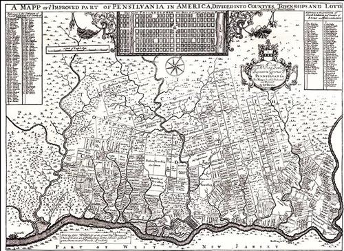
Holme used a simple method of blocking out land in the east end of Montgomery and Bucks Counties. He ran parallel lines northwestward from the Delaware River at intervals of one and one-half miles; each alternate line established a division line between townships, the intervening lines formed median or base lines within the townships, from which individual grants of land were measured. Horsham forms one of a tier of townships set apart in this manner, and extending from the Philadelphia county line through Hatfield Township. Similar tiers flank these townships both to the left and to the right.
Through Highways were projected along each of these parallel lines, when actually laid out, these highways occassionaly deviated from the straight lines of the survey, due to irregularities of terrain, but in a general way most of the southeast-northwest roads in the eastern end of Montgomery County and the adjacent section of Bucks County follow the old survey line laid down more than 250 [well over 300 years as of 2025] years ago. Township Line Road or Cottman Street, Susquehanna Road, Welsh Road, Horsham Road, County Line Road, Street Road and Bristol Road all follow closely the base lines found on Holme’s map.
For some reason no longer known, this plan was not followed out strictly in the case of the township later known as Horsham. Holme’s map shows all that part of the township lying west of Horsham Road as a part of the adjoining township, and the original patent to this land describes it as lying in Upper Dublin. This patent was issued in 1702. The present boudaries of the township were fixed shortly afterwards, probably at the time of the of its formal organization in 1717.
While the original survey lines were theoretically parallel and precisely southeast to northwest, the difficulties of surveying a comparitively level and densly wooded region were obviously great, and the transit instrument was not yet in use. Consequently later surveys show that Holme’s lines were not always either strictly parallel or directly northwest. Thus Welsh Road and Horsham Road incline about 5 degrees west of true northwest, while the County Line Road deviates only 3 degrees in the same direction. Furthermore, the first two roads are 509 rods apart on the average, or 29 rods more than one and one-half miles, while the County Line Road is about 20 rods less than one and one-half miles from Horsham Road at the southern end of the township, and slightly more than one and one-half miles at the upper end.
Horsham, therefore, forms a somewhat irregular parallelogram, with an average width of slightly more than 3 miles. Its length was determined by the measurements of the original grants; while land was granted along a straight line at the lower end, at the upper end the grant lying west of Horsham Road extended about 80 rods beyond the corresponding grant to the easy of the road, resulting in a broken boundary line. The average length is somewhat more than 5 1/2 miles, and the total area is about 10,750 acres, or a little less than 17 square mile.
The formal organization of the township is said to have taken place in 1717 (Bean’s History ). It is probable that the permanent limits were fixed and a name selected for the township at that time. Tradition states that the name was suggested by Thomas Iredell, one of the first settlers, in memory of his home in England. However, Iredell imigrated from County Cumberland on the Scottish border, and not from Sussex, where Horsham, England is located. On the othe other hand, it has recently been proved that Samual Carpenter, once the owner of nearly half the township, was born in Horsham, Sussex (Carpenter pp 1-2) and the same authority quotes a circumstantial story to the effect that the early settlers went to Carpenter and asked what name he would like for the township. However this may be, a deed of 1748 to land near Prospectville (Editor: intersection of Horsham Road and Limekiln Pike) (Orginal, Francis Lynch) states that Carpenter called his tract “Horseham” and that Hannah Carpenter’s deed to Horsham Meeting in 1718 (F 1, p235) describes the township as called or to be called Horsham” indicating a prearramngement to this effect. It may be reasonably be concluded from the evidence that Samual Carpenter, and not Thomas Iredell, provided the name for the township.